


EARTH.AI is VIZZIO’s patented platform that transforms satellite imagery and geospatial data into detailed, photorealistic 3D digital twins of urban environments.
Powered by advanced AI, EARTH.AI delivers real-time, high-precision visualizations that enable smarter planning, decision-making, and management for industries ranging from smart cities to manufacturing. With its rapid and scalable 3D modeling capabilities, EARTH.AI is redefining how we understand and interact with the world around us.
UN-MATCHED ACCURACY, SPEED AND SCALABILITY
SPEED & EFFICIENCY
VIZZIO build the world’s leading 3D modelling and visualisation software, enabling city-scale digital twins and mission-critical dashboards for governments and enterprises. We are a global leader in the production of highly detailed digital replicas of urban landscapes, enriched with semantic 3D data, made readily available for an array of uses including gaming, simulations, training, city planning, defence, sustainability and much more.
We map and model WORLD cities into high fidelity photorealistic 3D models, backed by an AI automated pipeline that segments and understands the semantics of satellite & street images, videos, point clouds and generates DIMENSIONALLY ACCURATE geo-specific & geo-typical parametric and hyper-photorealistic 3D digital twins. Complete Globe Coverage. No Aerial Photogrammetry needed.
GLOBAL COVERAGE
The ability to capture and create detailed 3D models of any city on Earth without relying on traditional drone-based photogrammetry represents a revolutionary breakthrough. This approach eliminates the logistical, regulatory, and technical challenges typically associated with drone operations, such as restricted flight zones, weather dependencies, and the time-intensive nature of data collection. By bypassing these limitations, it significantly accelerates the process of urban modeling, enhances scalability, and opens up opportunities to map cities in regions where drone use is impractical or prohibited. This innovation has the potential to redefine urban planning, disaster management, and immersive virtual experiences by providing a faster, more accessible, and comprehensive solution for creating city-wide 3D visualizations.
GEOMETRICALLY PRECISE & DIMENSIONALLY ACCURATE
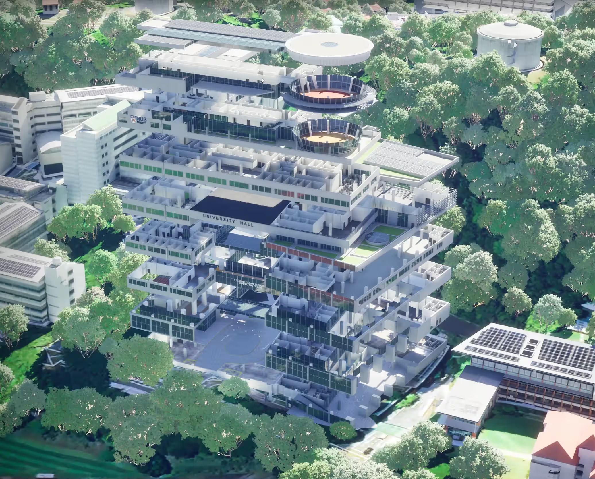
VIZZIO’s Patented AI technology revolutionises 3D city modeling, creating highly accurate digital twins of any location on Earth using satellite imagery and data from leading geospatial providers worldwide. This innovative process ensures geometrically precise and positionally accurate models that are always up-to-date, delivered through an incredibly fast, AI-driven workflow. No drones, aerial photogrammetry, or government permits required. Transform urban mapping with unparalleled efficiency and detail.
HYPER-PHOTOREALISTIC & VISUALLY STUNNING
Our faithful building facade texturing process combines artificial intelligence, heuristics, neural graphics and procedural methodologies. We used a VISION TRANSFORMER neural network, trained on 1500+ different cities across the globe, to classify each pixel into other classes, such as building, shadow, and eight different roof shapes. This unique and patented technique creates a photorealistic, life-like environment from satellite imagery and exogenous data. We can also integrate other relevant data, such as GIS, street names, points of interest, and zoning information. This integration enhances the accuracy and utility of the model.
NO AERIAL PHOTOGRAMMETRY NEEDED
Unlike Google and other Aerial Photogrammetry companies, we build DIMENSIONALLY-ACCURATE, PHOTOREALISTIC, REAL-TIME, SEMANTIC 3D DIGITAL TWIN OF CITIES via deep learning and satellite imagery on a global scale, backed by an AI automated pipeline that segments and understands the semantics of point cloud and generates usable parametric and 3D models.
The challenge of utilising UAV photogrammetry to construct 3D city models lies in the costly and time-consuming nature of the process. Furthermore, obtaining government permits for no-fly zones adds another layer of complexity. This costly and protracted procedure complicates the task of regularly updating the 3D map to ensure its relevance.
The advancement in satellite imagery resolution has significantly improved the feasibility and quality of 3D mapping from space. VHR satellites can capture imagery with a resolution of less than 0.15 meter per pixel, allowing for the highly-detailed mapping of urban landscapes.
Utilising satellite imagery and data from top geospatial providers, we can accurately model any location worldwide. The models are geometrically and positionally precise, updated through a fast, AI-driven process. The texturing of building facades is achieved using a neural network trained on imagery from over 1500 cities, classifying details like building elements and roof shapes to create photorealistic environments. Additional data integration, such as GIS and zoning information, further enhances the model's accuracy and utility.
Advanced machine learning and a geographic pipeline allow VIZZIO to efficiently parse raw satellite imagery and extract detailed semantic information, continually refining the accuracy of their digital twins and outperforming traditional aerial photogrammetry methods.
HYPER-PHOTOREALISTIC & VISUALLY STUNNING
Our faithful building facade texturing process combines artificial intelligence, heuristics, neural graphics and procedural methodologies. We used a VISION TRANSFORMER neural network, trained on 1500+ different cities across the globe, to classify each pixel into other classes, such as building, shadow, and eight different roof shapes. This unique and patented technique creates a photorealistic, life-like environment from satellite imagery and exogenous data. We can also integrate other relevant data, such as GIS, street names, points of interest, and zoning information. This integration enhances the accuracy and utility of the model.
the world’s most comprehensive whole-earth digital twin
VIZZIO is building the world's most comprehensive whole-Earth digital twin, powered by AI, one city at a time. Our immersive 3D models offer real-world cities as digital twins, instantly accessible for applications like gaming, simulations, training, and architecture. Using advanced machine learning and geographic pipelines, we transform raw satellite imagery into highly accurate, geometrically precise 3D environments. With additional data integration from sources like GIS and zoning information, our digital twins become even more useful and photorealistic.

BLAZING FAST. GLOBAL COVERAGE. ALWAYS UPDATED.
Our AI-driven process enables us to efficiently model any location globally, outperforming traditional methods like aerial photogrammetry. VIZZIO’s 3D maps are flexible, cost-effective, and delivered quickly, supporting a wide range of industries, from city planning and disaster management to infrastructure and environmental monitoring. As satellite technology advances, VIZZIO will continue to push the boundaries of space-based Earth observation, unlocking immense value with up-to-date 3D city models.
Transforming Satellite Data into Photorealistic 3D Cities
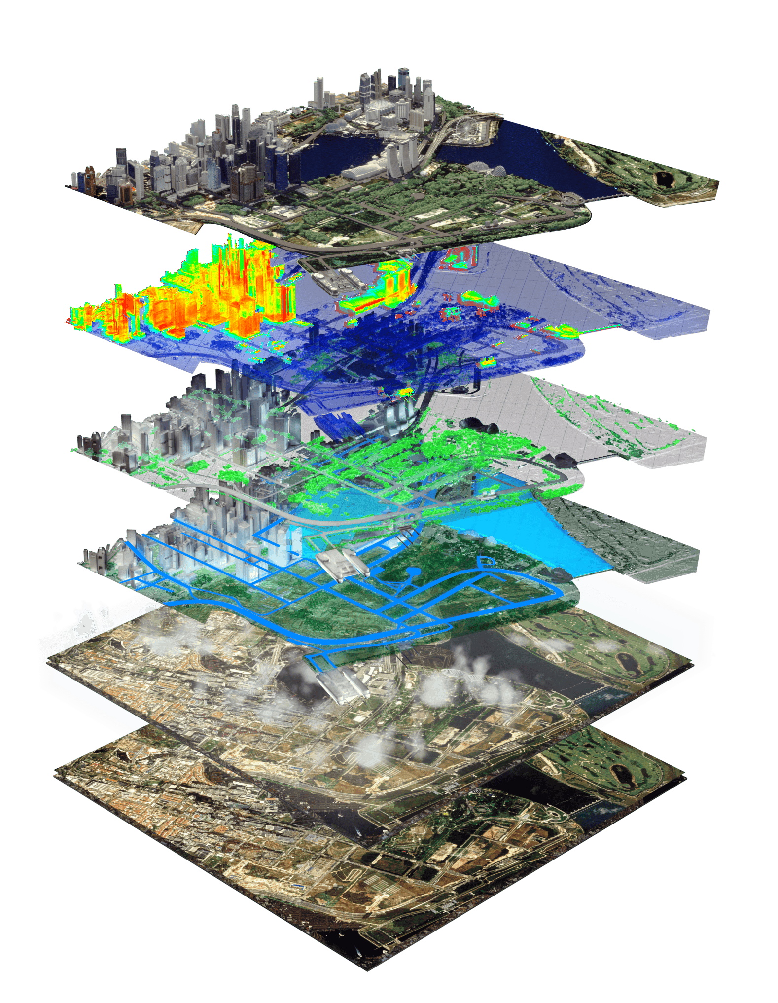
Our advanced 3D mapping process transforms satellite data into photorealistic, geo-specific 3D city models with unmatched precision. Starting with stereo images from low-orbit, sun-synchronous satellites, we use AI-driven enhancements to correct atmospheric distortions, remove shadows, sharpen resolution, and reduce noise. The data is segmented to extract building geometry, road networks, and other critical details, while multi-temporal imagery is super-resolved for exceptional accuracy. The result is an optimized 3D digital twin, ready for geospatial analysis, urban planning, and real-time applications. This scalable solution requires no drones or LiDAR, redefining how cities are mapped and understood.
faq
We use proprietary AI-driven technology to transform raw satellite imagery and geospatial data into highly accurate, photorealistic 3D models. Our machine learning algorithms classify building elements, road networks, and other infrastructure to create precise digital twins without the need for drones or manual surveying.
Our technology supports a wide range of industries, including smart cities, real estate, construction, manufacturing, energy, logistics, and environmental monitoring. From infrastructure planning to simulations and security, VIZZIO’s digital twins provide valuable insights for better decision-making and operational efficiency.
VIZZIO’s models are geometrically and positionally accurate, with sub-30 cm precision. Our technology provides high-resolution, real-time data that continually updates, ensuring that the models are always current and highly reliable.
VIZZIO’s 3D models offer unmatched accuracy, speed, and cost-efficiency. They provide real-time insights, helping businesses optimize workflows, improve infrastructure management, enhance safety and security, and support sustainability goals. Our technology is scalable and adaptable for any location worldwide.
Yes, VIZZIO can accurately model any location on Earth using satellite imagery and data from top geospatial providers. Our AI-driven process ensures that we can create models for cities, regions, and industrial facilities anywhere in the world.
Traditional 3D mapping methods often rely on aerial photogrammetry or manual data collection, which can be time-consuming and costly. VIZZIO’s AI-based platform automates this process, delivering faster, more cost-effective, and scalable 3D models with no need for drones or on-site data collection.
VIZZIO’s models are updated in near real-time, depending on the availability of satellite data. Our AI-driven workflow ensures that the 3D twins are always current, providing users with the most up-to-date visualizations and insights.
VIZZIO’s 3D solutions can be tailored to your business needs. Whether you're in urban planning, real estate, manufacturing, or another industry, our team can help you implement 3D digital twins to optimize operations, enhance safety, and make data-driven decisions.
Bring Your Data to Life
BEING ABLE TO 3D-MAP ANYWHERE GLOBALLY with HIGH ACCURACY IS A MASSIVE GAME CHANGER